ABOUT KINKOWAN
Kinkowan Bay was formed
when a major volcanic eruption took place,
creating movement in the earth's crust.
Despite the fact that this is an inland bay,
the sea here reaches a remarkable depth
of 237m at its deepest point.
The bay also features Sakurajima,
one of a few active volcanoes in the world,
and a submarine volcano,
which is also active.

A national park of
volcanic landforms
Kirishima-Kinkowan National Park was formed when Kirishima-Yaku National Park was divided up into "Yakushima National Park," which is home to the area's island ecosystems, and "Kirishima-Kinkowan National Park," an area of volcanic landforms. The Aira Caldera was also added to Kirishima-Kinkowan National Park at this time.
Kirishima-Kinkowan features expanses of land and ocean that bear the mark of volcanic activity. It is home to a group of 20 volcanoes, large and small, including Mt. Sakurajima (a volcano which continues to be active to this day), and a volcano which lies under the sea. The Aira Caldera, meanwhile, is a spot of immense significance as an important reminder for the people of today about the terrible strength of the eruption that created it.

A caldera beneath the sea
Kinkowan Bay was carved out through a series of massive volcanic eruptions.
In the inner region of Kinkowan Bay lies the Aira Caldera, a hollow created when an area of land collapsed due to a massive eruption 29,000 years ago. Great masses of debris ejected by the volcano in the eruption can be seen all over Southern Kyushu, where they are given the name of "shirasu." The caldera is the site of Mt. Sakurajima, one of Japan's few active volcanoes, and of a submarine volcano in the innermost part of the bay which also continues to be active even today. At the outlet of the bay lies the even more ancient Ata Caldera, formed around 110,000 years ago.
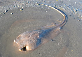
Deep-sea fish live in the bay, which reaches a depth of 237m at its deepest point. Featuring complex formations and warmed by the "kuroshio" (a warm north-western ocean current) that flows into it, Kinkowan Bay is home to a diverse variety of organisms.
LIVING ORGANISMS
SEEN IN SHIGETOMI BEACH
Shigetomi Beach is made up of a 53-hectare expanse of tidal flats, the largest such area in the inner Kinkowan Bay.
Connecting the sea and the land together, these tidal flats serve the role of purifying the seawater from the bay,
and are also a habitat and feeding ground for many species of wildlife.
-
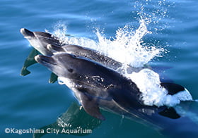
- Indo-pacific
bottlenose dolphinPeriod: All Year -
- Indo-pacific
-
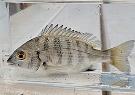
- Black PorgyPeriod: All Year
-
-
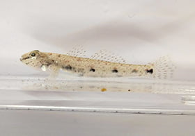
- Sharp-nosed Sand GobyPeriod: All Year
-
-
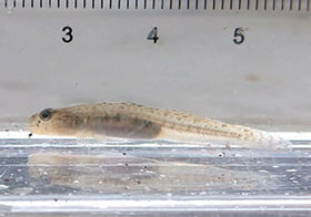
- Chikuzenhaze
(Gymnogobius uchidai,
a species of goby)Period: All Year -
- Chikuzenhaze
-
- Red StingrayPeriod: All Year
-
-
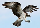
- Western OspreyPeriod: All Year
-
-
- Black-faced
spoonbillPeriod: October to May -
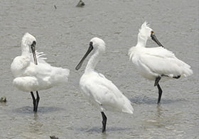
- Black-faced
-
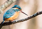
- Common KingfisherPeriod: All Year
-
-
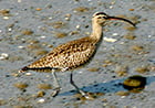
- WhimbrelPeriod: March to May/September to November
-
-
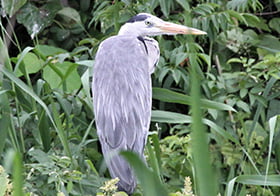
- Grey HeronPeriod: All Year
-
-
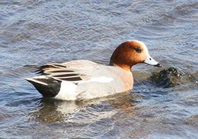
- Eurasian WigeonPeriod: November to March
-
-
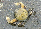
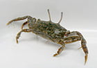
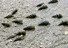
- Mamekobushi crabPeriod: March to November
-
-
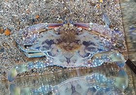
- Blue Swimmer CrabPeriod: All Year
-
-
- Fiddler crabsPeriod: April to November
-
-
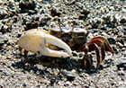
- Sentinel crabPeriod: May to October
-
-
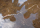
- Straw wormPeriod: All Year
-
-
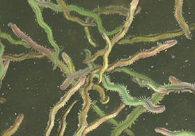
- Yamatokawagokai
(Hediste diadroma,
a species of ragworm)Period: March -
- Yamatokawagokai
-
- Sea snailPeriod: March to December
-


GEOGRAPHICAL
FEATURES
OF THE INNER
KINKOWAN BAY
The geographical features of Kinkowan Bay are characterized by its depth,
which reaches 206m deep in the innermost part, and by its submarine volcano.

Kamitsukuri Islands 神造島
The Kamitsukuri islands is the name given to a group of three islands: Hetakojima, Bentenjima and Okikojima. They are characterized by their unusual geology, which developed when a layer of rhyolite (a volcanic rock) from the ocean floor bulged upwards and was then gradually worn away over many years.

Terayama 寺山
Terayama Observation Platform in Yoshino-cho, Kagoshima City, which stands 400m above sea level, is the perfect spot for taking in the view of the Kirishima mountain range to the north, Kinkowan Bay below and Sakurajima in front of you!!

Wakamikobana 若尊鼻
Wakamikobana is a spot directly facing Kirishima City's coastline. At the edge stands a tiny shrine, which according to legend marks the spot where Yamato Takeru (a prince who is believed to have lived in the 8th century) landed when he arrived to drive out the Kumaso, an ancient people who originally occupied this area.

Kanze (God’s Shoal) 神瀬
Kanse Lighthouse stands among the currents flowing between Sakurajima and Kagoshima City. At low tide, an expanse of sandy beach appears at the foot of this white lighthouse. Surrounded in coral reefs and seaweed beds, this area is teeming with fish.

Mt. Takatoge 高峠
Takatoge Pass is an observation platform standing at an elevation of 722m to the northeast of Tarumizu City. Visitors here can enjoy a spectacular 360-degree panoramic view around them. In spring, the slopes of the mountain are brightened with the flowers of the 100,000 wild azalea bushes that grow here.

Shinjima Island 新島
During the Anei eruption in Japan's Edo period (1603 to 1868), eruptions also occurred on the sea floor and magma raised (uplifted) the sea floor up. Many faults were also formed during the uplift.